Wednesday, July 15, 2020
Mt Harvey - from the backside
Mt Harvey has been on my list of local peaks to bag. I can still recall camping out in Magnesia Meadows on our Howe Sound Crest Trail(HSCT) trip with the east face of Mt. Harvey looming over us. GR suggested we take a crack at it as our first foray into the mountains for the year. He's been up many times, but this would be my first.

Parking restrictions in Lion's Bay (the starting point) have become increasing restrictive the last few years, and there's only 8 parking spots at the trailhead, so we parked at the school and walked up the road to trailhead. It's intoxicating, that first step into the woods, even though it's an old gravel logging road, not a real trail. We met some kids going to tunnel bluffs, taking the Brunswick mountain trail, as we continued up the road to The Lions and Mt. Harvey trails.
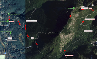
We must of have been yakking as somehow we missed the trail up to Harvey (oops) and (unknowingly) continued on the trail to Lions. At a juncture where the real Lions trail starts, we met two German women hiking up the Lions to camp. We carried following a sign that read 'Harvey Valley'. I was a bit suspicious but I figured it would also lead to the mountain. GR kept saying 'I don't remember this part'. After bushwacking through a swampy valley ('I really don't remember this part'), we decided to stop and get the map out. I took a GPS reading on my phone, and we identified our location as way off the Harvey trail, on a seldom used trail that used to be a road up Harvey Valley.
It was decision time. Go forward or back. We could see that we could possibly carry on, but didn't know the route and wasn't sure about the climb up the east face of Harvey. We delayed, and hiked a bit more until hunger struck. I sat down and ate and filled my bottle from a stream. We had decided to turn back but then did another GPS reading and saw how close we were to the HSCT, so on we go. (See map below)

It was nice to see the HSCT sign and we started north back towards Magnesia Meadows, then taking the Mt. Harvey east trail. This was the part we were concerned about, but it turned out to be a beautiful scramble up a not too steep face that turned out to be the highlight of the trip.

On top we met a young woman from Chilliwack, who had hiked from our same starting point to Brunswick, then along the HSCT south and up the same scramble as we had just done. She was glad to see us, as she wasn't sure she could go down the west side of Harvey. After a few pics and a nice chat she started down the west side and we followed a few minutes after.
All in all, a great hike. It's always great to fit in a looper.

Parking restrictions in Lion's Bay (the starting point) have become increasing restrictive the last few years, and there's only 8 parking spots at the trailhead, so we parked at the school and walked up the road to trailhead. It's intoxicating, that first step into the woods, even though it's an old gravel logging road, not a real trail. We met some kids going to tunnel bluffs, taking the Brunswick mountain trail, as we continued up the road to The Lions and Mt. Harvey trails.
We must of have been yakking as somehow we missed the trail up to Harvey (oops) and (unknowingly) continued on the trail to Lions. At a juncture where the real Lions trail starts, we met two German women hiking up the Lions to camp. We carried following a sign that read 'Harvey Valley'. I was a bit suspicious but I figured it would also lead to the mountain. GR kept saying 'I don't remember this part'. After bushwacking through a swampy valley ('I really don't remember this part'), we decided to stop and get the map out. I took a GPS reading on my phone, and we identified our location as way off the Harvey trail, on a seldom used trail that used to be a road up Harvey Valley.
 | |
| The Lions from our first GPS reading. Different view from the west and north. |

It was nice to see the HSCT sign and we started north back towards Magnesia Meadows, then taking the Mt. Harvey east trail. This was the part we were concerned about, but it turned out to be a beautiful scramble up a not too steep face that turned out to be the highlight of the trip.

On top we met a young woman from Chilliwack, who had hiked from our same starting point to Brunswick, then along the HSCT south and up the same scramble as we had just done. She was glad to see us, as she wasn't sure she could go down the west side of Harvey. After a few pics and a nice chat she started down the west side and we followed a few minutes after.
 | |
| Leaving Mt. Harvey. Horseshoe Bay and Bowen Island in view |
All in all, a great hike. It's always great to fit in a looper.

Monday, June 24, 2019
Kettle Valley Railway
GR and I decided to try something different from our usual mountain hikes, and ride the Kettle Valley Railway (KVR) this year. It took a bit of prep; fitting the bikes, getting a little bit different gear, going on a few training runs, but by early June we were ready.
This travelogue is meant to be a companion to the 'Cycling the Kettle Valley Railway' (Dan and Sandra Langford). This book was written in the 1994 and updated in 2002. It's out of print but you can still buy used copies through Amazon. The history is detailed, engaging, and still relevant. Surprisingly, a lot of the traveling recommendations are still accurate, but not all, so be careful!
The first problem was weather. We're both fair-weather campers, no point getting wet if you can delay for a day or two. We tried to apply that to our 3 day overnighter for the KVR, but the long term weather forecasts weren't consistent, and in the end we (or I) decided to go with our original target date and hope for the best. More on that later.
The plan was to drive to Penticton, stay with sister Sue and Brian, have them to drive us to Midway with bikes for the drop off, then ride the KVR westward back to Penticton. Nice!
Day 1 - Midway to Beaverdell
Elapsed Time: 9 hrs.
Rolling Time: 5 hrs, 52 min.
Distance: 71 km.
Average: 12.1 km/hr
After a hearty breakfast from the support team, we drove to Midway for the drop off. Had a nice chat with the woman in the Midway station, got a map, and up-to-date news, then we're on our way.


First stop was at Rock Creek campground. There's a store here where GR purchased some refreshments. The campground is a large green field by the river, with all the amenities you need. There seems to be public campground on the opposite side of the river. Not quite the right location for us to camp, too close to our starting point. Also, if coming the other way (north), it's not that far to Midway, so would probably keep going. Be aware the store (and maybe the campground office) close at 5pm.
 |
| Rock Creek Station and Campground |
Travelled through a number of stations, on the look out to stop for lunch at Rhone Station. The book calls this a KVR Cyclists rest stop as initiated by Paul Lautard. It's a great place to stop and have lunch, and by the writings on the walls, it looks like it has been well used in the past. There's a railway car (locked) that looks like an office and a covered area. However there was no one around and no water. Had a nice lunch there before moving on.


We were looking for a swimming hole mentioned in the book(km 47.3). Looking back, I think it's where we saw a picnic table on the river side, but for some reason we didn't identify it at the time. We eventually stopped at about km 50, rode across a small field to the Kettle River, and had a quick dip.
 |
| Kelly R. Bridge 47.6km |
Day 2 - Beaverdell to McCullogh station.
Elapsed Time: 8.5 hrs
Rolling time: 5hrs. 11 min
Distance: 58km
Average: 11.1 km/hr

On our way the next morning by 10am. The weather looked cloudy, but we were hopeful. Quick stop at Carmi station to get the book stamped (there's still an old stamp at the kiosk).

Then onto Arlington lakes, where we stopped for lunch. We thought the big slough on the west of the trail was the lake, so stopped on a ledge overlooking for lunch, but it turns out the campground and day use area is another km further on. Nice campground that's also accessible by car. On a nicer day, we would have stopped for a swim, but as the clouds were looming, we carried on.

Shortly after leaving Arlington lakes, the rain started. It was start and stop for while, but then it didn't stop. There were still a few obstacles as well. Some large puddles that we skirted the edges of, and yet another (near Wolf Creek km 105.4) where there was no skirting. Someone has nicely carved a 50m push-your-bikes detour through the woods to get around this one.
 |
| There's no going through that! |
 |
| Push through - Dennis got a flat here from a thistle |
The Hydraulic Lake forestry campground just prior to McCullogh station(follow the signs) looks very attractive, but we were hoping that the McCullogh resort would be open and we could get a cabin. Alas, the resort was closed (this is one of the few places where the book does not match reality). 'No Trespassing' signs on the locked gate. Fortunately, we discovered a Plan B that successfully got us through the night. << Details Redacted>>
The Hydraulic Lake campground has a camp caretaker that collects the fee (not sure, probably $15), and sells water and wood. We got our water from Hydraulic Lake and treated it. There's no other water in the campground other than what the caretaker has.
There's cel-phone service here, so after checking the weather for the next day (not good), I made a phone call to Chute Lake Resort and booked a room for the next night. We had planned on camping, but we knew we would be wet and opted for the easier option.
Day 3 - McCullogh Station to Chute Lake Resort
Elapsed Time: 7 hrs
Rolling time: 4 hrs.
Distance: 49.5km
Average: 12.2 km/hr
Cold and gloomy as we started out from McCullogh station. Fortunately we were warm and dry to start. After filling up with water again at Hydraulic Lake, we carried on. This was supposed to be our glory day: riding through the Myra Canyon trestles. We stopped at Myra Station for a coffee. There's a food truck, and bike rentals here. Lots of people drive to Myra station, probably from Kelowna, rent bikes and ride to Rose station and back.
 |
| Myra Station - Hot coffee! |
We got a little ways into the trestles when the rains started. We stopped at a resting hut to wait out the rain, but it wasn't stopping. After putting on all our clothes, plastic bags on my feet, and chewing down as much of Brian's home made deer sausage as we could, we braved the rain and pushed through the trestles. We will definately need to go through this again when we can look around!
 | |
| Bellvue Trestle - km 155.2 |

Eventually made it to Chute Lake Lodge. That was a glorious site to behold, and expanded our room count to one each. Good idea, as we had our rooms draped with wet clothes.

Had a hot shower and down to the restaurant for burger and beer before 7pm closing.(Chute Lake Lodge: $115 per room. $5 for towel, $15 burger, $6 beer. Get there early. Restaurant closes at 7pm. Office was closed by 8pm)
At Chute Lake Lodge we met another bike traveler named Dennis. He had a somewhat different plan: travel light with no tent or sleeping equipment and stay in lodges or B & Bs. The previous day he traveled from Greenwood to an AirBnB near Carmi Station (search for AirBnB near Beaverdell). Then was planning on pushing through directly to Penticton. However, he ended up staying a night at Chute Lake Lodge where we met him, mostly because of ghastly weather and not one, but two flat tires near Wolf Creek. Dennis is an adventure tour guide and Ironman so it was encouraging that we could handle the same trail as him. It was a pleasure and inspiration to meet Dennis!
Day 4: Chute Lake Lodge to Penticton.
Elapsed Time: 4 hrs
Rolling Time: 2hr 26 min
Distance: 42km
Average: 17.2 km/hr
Sun was shining as we left the lodge at 10am, but it was still cool. We stopped about 4 times on the ride down to Penticton to progressively shed layers of clothes. The nice part: it's all downhill, but there's some sandy bits. Dennis had told us it would be a 'soft' ride down. I thought he meant muddy, but it's sand. You can steer through it with momentum, but I sure wouldn't want to be climbing this bit.
 | |
| GR and Dennis dropping some layers |

Stopped and looked at Adra tunnel, which is closed as of this writing. Now that that the trestles have been re-furbished, it appears the next project for the KVR is to open this tunnel. For now, there's an easy detour.

Interesting stop at the rock ovens in Rock Ovens Park. The KVR has many rock ovens along it's path. According to the book, they were used to bake fresh bread for the workers. This park exposes two of them in what was once a workers camp.


After the 'Little Tunnel', civilization hits. The trail is maintained, and the ride is much smoother. Day trippers coming up from Penticton are a common sight. Nice glide down through the vineyards (not stopping for any tastings!) with a great view of Okanagan lake, and into the city.

Interesting that the KVR goes right through the heart of Penticton, as what looks like a normal bike lane. It was easy to find our way from there and head back to base camp.
Our wonderful support team (Sue and Brian), had cold beers and plates of ribs ready for us. Thanks to them for hosting, drop-off and fueling!
Monday, November 19, 2018
Baden Powell - Part 4
Baden Powell Trail - Lynn Headwaters to Deep Cove
I had to do this one in two shifts as the Pipeline bridge, crossing the Seymour river is under construction.
I always like crossing the Lynn Canyon suspension bridge. A free and much more immediate experience than the Capilano Suspension Bridge tourista extravaganza. The warning sign about jumpers is new.


Another beautiful trail following Lynn Creek then up, eventually crossing Lillooet Road.

There was a sign here saying that the trail couldn't get through at Pipeline bridge, but of course, I didn't believe, but it was true, so had to walk down through Capilano U.
Second try, started at the opposite (east) side of Pipeline. Crossed Mt. Seymour Rd. and Indian RiverRd,

Eventually to Quarry Rock, where there about 20 people lizarding in the sun. I joined them for a little nap, then the nice little 30 minute return from Quarry Rock back to (finally) the opposite endpoint of the Baden Powell. Four legs over a number of weeks. Done.

I had to do this one in two shifts as the Pipeline bridge, crossing the Seymour river is under construction.
I always like crossing the Lynn Canyon suspension bridge. A free and much more immediate experience than the Capilano Suspension Bridge tourista extravaganza. The warning sign about jumpers is new.


There was a sign here saying that the trail couldn't get through at Pipeline bridge, but of course, I didn't believe, but it was true, so had to walk down through Capilano U.
Second try, started at the opposite (east) side of Pipeline. Crossed Mt. Seymour Rd. and Indian RiverRd,

Eventually to Quarry Rock, where there about 20 people lizarding in the sun. I joined them for a little nap, then the nice little 30 minute return from Quarry Rock back to (finally) the opposite endpoint of the Baden Powell. Four legs over a number of weeks. Done.

Baden Powell - Part 3
Baden Powell Trail - Grouse Mountain to Lynn Headwaters.
Third leg of Baden Powell trail: Grouse mountain to Lynn headwaters park. Approx 12km.


Third leg of Baden Powell trail: Grouse mountain to Lynn headwaters park. Approx 12km.
Caught transit (train, seabus, bus) right to the base of Grouse Mountain. Trail starts right where the Grouse Grind starts, but you go east, not north!
It really is an urban trail. You come out to some roads at times, and you can sometimes hear the city, but there's enough bumps and hills to still make it a challenge.

The trail is well groomed, nice flat rocks laid out on the trail. I was wondering about this until I realized this section is part of the famous North Shore mountain biking network. See the pic of one of the bike ramps.

Eventually comes out at Lynn headwaters, with a nice view of Lynn creek from the Varley trail on the way back to bus.

Wednesday, October 17, 2018
Baden Powell - Part 2
Baden Powell Trail - Cypress Mountain to Grouse Mountain (Cleveland Dam)
I really outsmarted myself on this one. I didn't plan this or think about this beforehand (not sure why), but this is all downhill. Nice. Start at the top of Cypress and end up at the neighbourhoods on the way up to Grouse mountain. Probably about an 800 metre loss of altitude. That's why it was so hard going the other way the last time I did this leg.

The trail starts close to Hollyburn lodge, and takes a nice run part way up Hollyburn mountain where it joins the cross country ski trails. It's a bit strange, as you could probably start at the cross country parking lot, but that would be cheating.
I really outsmarted myself on this one. I didn't plan this or think about this beforehand (not sure why), but this is all downhill. Nice. Start at the top of Cypress and end up at the neighbourhoods on the way up to Grouse mountain. Probably about an 800 metre loss of altitude. That's why it was so hard going the other way the last time I did this leg.

 |
| Cross country trail in the summer |
It's funny walking the cross country trails that we skied so many times with the kids when they were young. The hills look so small. They seemed so much bigger then.
After leaving the Cypress area, stopped off to see a few lakes just off the trail: West lake, and Blue Gentian lake (I loved the name, but the lake didn't quite live up to it).
After the lakes, there's a long slow descend going east. There seem to be a number of other access points to this trail. One of them being the 'Crossover Trail'. Someone has built a little bridge there using the old technique of splitting cedar into planks, rather than sawing. Good to see.

Not too far from here, the trail joins with the Cross Canada Trail, and pretty much follows the power lines east to Capilano Road. However, there are some interesting points. I remember the following steps from a previous hike.
On the left, from Nov 2017. On the right, this trip.


The trail passes through what I think of as 'old second growth'. The forest is uniform, definitely not the mixed bag you'll find in an untouched forest, with what look like 80-100 year old Douglas Fir. Maybe the old growth was logged 100 years ago and tree-planted not too long after? It's an eerie feeling, almost an optical illusion when you first come across it.

Eventually the trail enters upper parts of North Vancouver, crossing paved roads, and edging along the back yards of houses, eventually ending up at Cleveland Dam.
 Oct 12, 2018
After leaving the Cypress area, stopped off to see a few lakes just off the trail: West lake, and Blue Gentian lake (I loved the name, but the lake didn't quite live up to it).
 |
| Blue Gentian lake |
 |
| West lake. Sign for a different season. |
After the lakes, there's a long slow descend going east. There seem to be a number of other access points to this trail. One of them being the 'Crossover Trail'. Someone has built a little bridge there using the old technique of splitting cedar into planks, rather than sawing. Good to see.

On the left, from Nov 2017. On the right, this trip.


The trail passes through what I think of as 'old second growth'. The forest is uniform, definitely not the mixed bag you'll find in an untouched forest, with what look like 80-100 year old Douglas Fir. Maybe the old growth was logged 100 years ago and tree-planted not too long after? It's an eerie feeling, almost an optical illusion when you first come across it.

Eventually the trail enters upper parts of North Vancouver, crossing paved roads, and edging along the back yards of houses, eventually ending up at Cleveland Dam.

Tuesday, October 16, 2018
Baden Powell - Part 1
Finally finished the Baden Powell trail. This instalment was Horseshoe Bay to Cypress mountain: 12km.
(However, I decided to treat this end of round one as also the start of round 2, hence the 'Part 1')
(However, I decided to treat this end of round one as also the start of round 2, hence the 'Part 1')
 |
| I like this view. The leftovers from a bridge construction. |
Started from Horseshoe Bay, past Whyte lake, beautiful trail, except for the boulder field (markings bad, up and to the right!), then a bit of a scramble up to Eagle Bluffs.

I had hiked to the Bluffs before (coming the other way), and couldn't find the way down the other side. Now I know why. No markings when you come out of the bush. You just have to trust that going up, finding your own path, is going to work.

Then on to Cabin Lake, via Black mountain. The lake was gorgeous, nice and clear. A bit too chilly for a dip though.

The trail down from the lake is disappointing, gravel switchbacks. Probably much nicer in winter on snow shoes. But, a nice array of mushrooms...

Hitched a ride down from Cypress (no buses!) with an Australian quad from Wollongong. They were sightseeing, so did some tour guide schtick for them. I'm sure they liked it...
Caught a bus right into Vancouver. It's always nice when the transit option uses the HOV ace and bypasses traffic, especially when it's the Lion's Gate bridge.
My phone had died (trying out new GPS trail tracking app that eviscerates the battery), and I hadn't checked in with base camp(Jane) yet, so tried to find a pay phone. No go. They are all gone. All gone...
Asked the Skytrain police about pay phones. They shook their heads. I told them why I needed to call (check in with base camp). The young lad knew immediately what I meant (must have been a hiker). He opened a compartment so I could use their private phone. Nice.
Great day: nice weather, beautiful trail, nice people jumping at the chance help.
Oct 10, 2018
Oct 10, 2018
![]()